

Cart
0
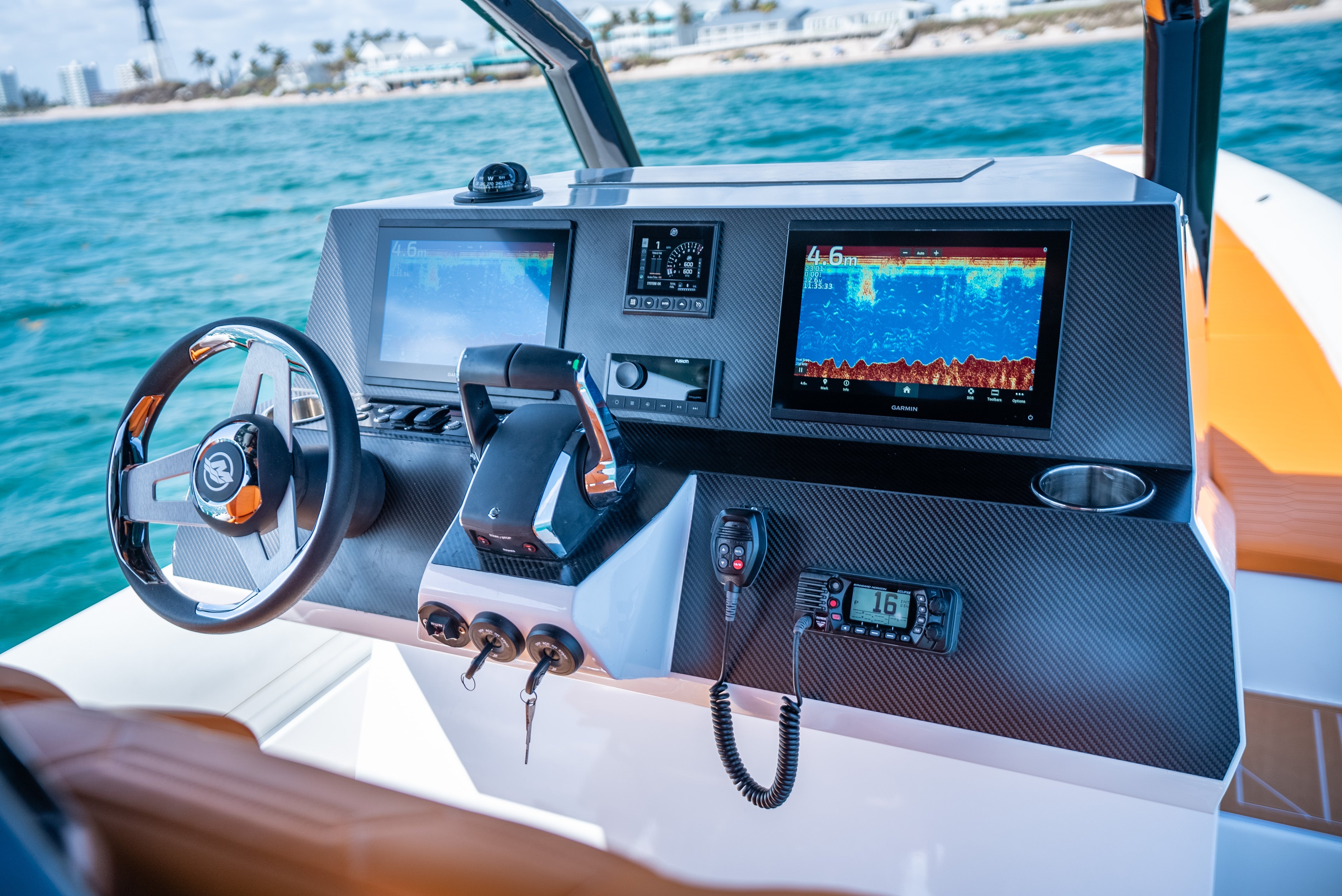
Best Marine GPS Systems
Gone are the days when boaters had to rely solely on paper charts, compasses, and dead reckoning to find their way. Today, marine GPS systems stand at the heart of modern navigation, offering unparalleled accuracy, safety, and convenience. From basic standalone chartplotters to advanced multifunction displays (MFDs), the breadth of available technology can be overwhelming. This comprehensive guide will walk you through everything you need to know about marine GPS systems—top brands, key features, installation tips, troubleshooting, and more—so you can confidently select the perfect GPS for your vessel.
Step 1: Understand the Core Functions of a Marine GPS
Before diving into the specific models or brands, it’s crucial to understand the primary functions and benefits that modern marine GPS units offer.
- Position Accuracy: GPS (Global Positioning System) pinpoints your exact location, often with an accuracy range of 3–10 meters.
- Navigation and Routing: Chartplotters display digital maps (charts) that let you plot routes, mark waypoints, and avoid hazards.
- Depth and Fish-Finding (Sonar Integration): Many GPS systems can pair with sonar to reveal underwater topography, fish schools, or structure.
- Weather and Radar Overlays: High-end systems may integrate radar or real-time weather overlays on your chart, enhancing situational awareness.
- Data Sharing and Networking: Advanced MFDs can connect to autopilots, AIS (Automatic Identification System), engine data, and more for an all-in-one helm station.
Having a clear grasp of these core features will help you narrow down your search to systems that match your specific boating needs, whether you’re a weekend angler, offshore cruiser, or liveaboard sailor.
Step 2: Top Brands in Marine GPS
Several reputable manufacturers dominate the marine electronics scene. While each brand has unique advantages, all produce reliable chartplotters and MFDs that cater to various budgets and requirements.
- Garmin: Known for user-friendly interfaces, a wide range of products, and frequent software updates. Garmin’s BlueChart cartography is detailed and intuitive for many coastal and inland waterways.
- Raymarine: Offers high-performance systems often favored by serious offshore and sailing enthusiasts. Their LightHouse OS is praised for its responsiveness and radar integration.
- Simrad: Popular among offshore anglers and cruisers, Simrad’s displays often integrate seamlessly with fish-finders, radar, autopilots, and more.
- Lowrance: Renowned for advanced sonar and fish-finding tech, Lowrance is a go-to for freshwater and coastal anglers wanting powerful navigation and fish-finding in one.
- Furuno: A longtime commercial and recreational brand, Furuno is celebrated for robust radar systems and solid chartplotter performance.
Exploring each brand’s ecosystem ensures that any future add-ons—like autopilots or AIS transceivers—will integrate smoothly, enhancing your overall navigation experience.
Step 3: Key Features to Compare
Selecting the right GPS involves more than just picking a brand. You’ll also want to compare specific features to ensure the device aligns with your boat type and cruising style.
- Screen Size and Resolution: Larger screens (7–12 inches or more) provide better visibility for detailed charts, especially on bigger boats.
- Touchscreen vs. Button Controls: Touchscreens are intuitive but can be harder to operate with gloves or in rough conditions. Button or hybrid controls may offer more precision.
- Preloaded Charts vs. Add-On Cartography: Some units come with regional charts included, while others require separate purchases of map cards for different regions.
- Connectivity Options: Look for Wi-Fi or Bluetooth support for software updates, data transfer, and connecting with mobile apps.
- Multi-Function Capabilities: Consider whether you want radar overlays, sonar, AIS data, engine monitoring, or autopilot integration on the same display.
- Ruggedness and Waterproof Rating: Marine electronics should ideally have at least an IPX6 or IPX7 rating to withstand spray and rain.
Clarifying these features will guide you toward a system that not only fits your current needs but also accommodates future upgrades or expansions.
Step 4: Comparing Marine GPS Models
Below is a table offering a snapshot comparison of popular models from major brands. Exact pricing and specifications can vary, but this chart can help you quickly identify systems worth considering.
| Model | Brand | Screen Size | Key Features | Approx. Price Range |
|---|---|---|---|---|
| EchoMap UHD | Garmin | 5–9 inches | Built-in Chirp sonar, BlueChart g3 | $$–$$$ |
| Axiom Series | Raymarine | 7–12 inches | LightHouse OS, RealVision 3D sonar | $$$–$$$$ |
| GO Series | Simrad | 5–12 inches | Broadband sonar, easy autopilot integration | $$–$$$ |
| HDS LIVE | Lowrance | 7–16 inches | LiveSight sonar, C-MAP chart compatibility | $$$–$$$$ |
| NavNet TZtouch3 | Furuno | 9–19 inches | Radar overlay, powerful networking | $$$$ |
While these price ranges are approximate, remember that additional costs—like transducers, radar domes, or additional chart packages—can raise the final investment. Assess how each model’s features align with the type of boating you do most often (fishing, cruising, sailing, etc.).
Step 5: Installing and Mounting Your GPS
A marine GPS is only as effective as its installation. Proper mounting, secure connections, and optimal placement all contribute to a reliable, easy-to-use navigation system.
- Choose a Visible Location: Install the display where the helmsman can easily glance at it without obstructing their forward view.
- Consider Sunlight Readability: Modern screens are often bright and anti-glare, but angling the display slightly can further improve visibility in harsh sun.
- Power and Grounding: Run dedicated power cables to a fused panel or battery switch. Ensure good grounding to avoid electrical noise or interference.
- Transducer Placement: If integrating sonar, position the transducer on the hull or transom per manufacturer guidelines. Avoid turbulence, intake ports, or prop wash.
- Network Connections: For multi-function devices, connect additional sensors (like radar or AIS) using NMEA 2000 or Ethernet cables. Label cables for easy troubleshooting.
- Sealing and Waterproofing: Use marine-grade sealant around any drilled holes to prevent water intrusion. Maintain drip loops in cabling to channel water away from connectors.
If you’re unsure about drilling holes or running cables, consult a qualified marine electrician. A clean, professional install can make all the difference in reliability and aesthetics.
Step 6: Essential Chart Types and Software
GPS units rely on digital charts to provide detailed waterways, depth contours, and navigational aids. Understanding which chart types and software options are available will help you get the most out of your device.
- NOAA Charts (U.S.): The National Oceanic and Atmospheric Administration provides free raster and vector charts for U.S. waters, often used by manufacturers as a base layer.
- Navionics: Known for detailed cartography, community edits, and SonarChart layers. Now owned by Garmin, many devices offer Navionics compatibility.
- C-MAP: Popular with Lowrance and Simrad users, C-MAP charts are known for depth shading, tides, currents, and harbor details.
- BlueChart g3: Garmin’s proprietary charts, blending Navionics data with their own for extensive coverage and clarity.
- LightHouse Charts: Raymarine’s LightHouse OS supports a range of chart formats, but many users opt for Navionics or official NOAA data for seamless integration.
Some charts also include satellite overlays, 3D perspectives, or advanced fishing layers. Evaluate which features matter most—be it fishing hotspots or precise depth shading for tight channel navigation.
Step 7: Maintaining and Updating Your GPS
Marine environments are harsh on electronics, and chart data can become outdated over time. Keep your GPS system in top shape by following these best practices:
- Regular Software Updates: Most brands offer free firmware updates that fix bugs, improve performance, and add new features. Check the manufacturer’s website or use Wi-Fi to update over the air.
- Chart Card Updates: If you use external SD or microSD charts, subscribe to update programs or purchase annual upgrades for the most recent navigational data.
- Clean the Screen Carefully: Use a soft, microfiber cloth and gentle cleaner to avoid scratching the display. Salt crystals can act like sandpaper if rubbed too hard.
- Secure Connections: Periodically check cables and connectors for corrosion, especially if you operate in saltwater. Use dielectric grease or corrosion inhibitor on plugs.
- Environmental Protection: When not in use, cover your GPS screen or helm with a protective cover to shield it from UV rays and water exposure.
Regular maintenance not only extends the life of your device but also ensures that you’re navigating with accurate, up-to-date information—crucial for avoiding shallow spots or newly added hazards.
Step 8: Using Your GPS for Safe and Efficient Navigation
A GPS unit is more than just a moving map display. Maximize its potential by learning key functions and best practices for real-world navigation.
- Waypoint and Route Planning: Pre-plan your journey by marking waypoints at key turning points, marinas, anchorages, or fishing spots. Then, create a route to follow.
- Track Recording: Many devices let you record your track. This feature is useful for reviewing your path, especially in unfamiliar waters or if you want to revisit a prime fishing location.
- Anchor Alarms: If your GPS supports it, set an anchor drag alarm. The system will alert you if your boat drifts outside a predefined radius.
- Depth Shading: Customize depth color ranges to quickly identify shallow areas that match your draft limitations.
- Radar and AIS Overlays (If Equipped): Overlaying radar returns or AIS targets on your chart helps you avoid collisions and see hidden obstructions in low-visibility conditions.
Regularly practice route creation, track interpretation, and alarm setups so you’re comfortable utilizing these features in dynamic situations, such as nighttime navigation or foggy weather.
Step 9: Troubleshooting Common GPS Issues
Even the best systems can encounter glitches or user errors. Knowing how to troubleshoot basic problems can save you stress (and potential danger) on the water.
- Signal Loss or Weak Reception: Check antenna connections or ensure you aren’t blocking the antenna with large metal objects. Reset the device if necessary.
- Inaccurate Position or Heading: Confirm that your device has the correct map datum and that heading sensors (if any) are calibrated. Sudden inaccuracies might also indicate external interference.
- Screen Freezes or Slows Down: Reboot the system, close unnecessary applications, or update firmware. Some complex overlays (radar, sonar, AIS) can tax older hardware.
- Intermittent Power Loss: Inspect the wiring, fuses, and battery connections. Corrosion or loose wiring is a frequent culprit for power issues.
- Map Layers Not Displaying: Ensure chart cards are correctly inserted and recognized. Update or reinstall chart data if corruption is suspected.
If issues persist, consult the manufacturer’s support documentation or contact a local marine electronics technician. Early troubleshooting can prevent more significant failures during critical navigation.
Step 10: Future Trends and Upgrades
Marine navigation technology continues to evolve. Staying aware of emerging trends can help you decide if and when to upgrade your system.
- Real-Time Sonar Imaging: Forward-looking sonar is becoming more mainstream, helping boaters see obstacles or the bottom contour ahead of their bow.
- Augmented Reality (AR) Overlays: Some premium displays now offer AR, merging camera feeds with chart data to highlight buoys, channels, and hazards on-screen.
- Integration with Mobile Devices: Many brands provide apps that let you plan routes on a tablet or phone, then sync them to your onboard GPS via Wi-Fi.
- Cloud-Based Updates: Instead of manually uploading chart updates, newer systems may seamlessly download and install incremental updates from the cloud.
- Precision GNSS (Global Navigation Satellite Systems): Some newer devices use not just GPS but also GLONASS, Galileo, or BeiDou satellites for improved accuracy.
Keeping an eye on these advancements ensures your marine GPS setup remains cutting-edge, improving both safety and the overall boating experience.
Top 10 Most Searched Questions and Answers on Marine GPS Systems
-
Q: Do I really need a dedicated marine GPS if I have a smartphone or tablet?
A: While apps on mobile devices are helpful, dedicated marine GPS units are built to withstand tough conditions and offer specialized features like sonar integration. Their antennas also deliver more reliable signals in offshore settings. -
Q: How accurate is a typical marine GPS?
A: Most units offer 3–10 meters of accuracy under normal conditions. Some high-end models with differential signals (DGPS) or WAAS can pinpoint within a meter or two. -
Q: What is the difference between a chartplotter and a fish finder with GPS?
A: A chartplotter focuses on navigation charts and routing features, while a fish finder emphasizes sonar readings of the water column. Many modern devices combine both into a single unit (MFD). -
Q: Are radar and AIS essential add-ons for coastal cruising?
A: They’re not mandatory, but radar helps you navigate in poor visibility, and AIS improves situational awareness of other vessels. They’re highly recommended for extended or night passages. -
Q: How often should I update my charts?
A: Updating at least once a year is wise, especially if cruising in rapidly changing coastal areas. Some boaters update before major trips or at the start of each season. -
Q: Can I install my GPS by myself?
A: Yes, many boat owners do a self-install. However, be comfortable with running wires, drilling mounts, and sealing penetrations. If unsure, professional installation might be safer. -
Q: Will my GPS work in remote or offshore locations?
A: GPS signals are available globally. However, chart coverage depends on your map data. Ensure you have charts for the regions you plan to navigate. -
Q: What is a “multifunction display” (MFD)?
A: An MFD is a central display unit that can integrate GPS charts, sonar, radar, AIS, and engine data. It simplifies the helm by providing multiple data streams on one screen. -
Q: Do I need an external antenna for my GPS?
A: Many devices have built-in antennas that work fine in open console areas. For enclosed bridges or sailboat cabins, an external antenna might improve signal reception. -
Q: How do I protect my GPS screen from salt spray or UV damage?
A: Most marine units are water-resistant and UV-treated. Still, consider using a protective cover when not in use, and clean the screen gently after each outing to remove salt deposits.
Sample Decision Flowchart for Choosing a Marine GPS
| Question | Choice A | Choice B | Likely GPS Solution |
|---|---|---|---|
| Freshwater or Saltwater Use? | Freshwater Lakes and Rivers | Coastal or Offshore | If freshwater-focused, a smaller unit with built-in sonar could suffice. Offshore boaters might need a larger MFD with radar/AIS support. |
| Primary Activity? | Fishing-Focused | Cruising/Sailing | Anglers benefit from advanced sonar and fish-finding. Cruisers and sailors want chart detail, radar overlays, and AIS data. |
| Budget Range? | $500–$1,000 | $2,000+ | Lower budgets can explore basic chartplotters. Higher budgets might choose top-tier MFDs with large screens and networked features. |
| Boat Size? | Under 25 Feet | Over 25 Feet | Smaller vessels often manage with a 5–7 inch display. Larger boats favor 9–12 inch (or bigger) screens for multi-data overlays. |
Conclusion
A dependable marine GPS system is one of the most critical pieces of equipment aboard any boat, enhancing safety and making every outing more enjoyable. By identifying your navigation requirements—freshwater fishing, coastal cruising, offshore passage-making, or anything in between—you can choose a system that aligns perfectly with your boating style. Remember to weigh factors like screen size, chart capabilities, integration options, and brand reputation.
Once you’ve selected your ideal unit, invest the time in proper installation and ongoing maintenance. Updating software, cleaning connectors, and backing up your routes or waypoints will keep your device running smoothly season after season. If you’re looking for additional marine accessories, console upgrades, or specialized gear to complement your GPS setup, browse CenterConsoles.myshopify.com. And for broader insights into marine technology, boat care, or gear reviews, visit NovielliBoats.com.
With the right marine GPS at your helm, you’ll have greater confidence navigating new waters, reaching distant fishing hotspots, or safely returning to port in changing weather. As technology continues to evolve, your onboard navigation will only become more accurate, intuitive, and interconnected—helping you explore the seas with peace of mind.